Inside NAWDIC: How a modified Gulfstream G550 is tracking the birth of Europe’s winter storms

Every winter, the North Atlantic quietly shapes life across Western Europe. Storms born thousands of kilometres offshore sweep in with little warning, bringing floods, gale-force winds, and sudden cold snaps that disrupt transport, damage infrastructure, and, at times, put lives at risk.
Yet despite its outsized influence on European weather, the Atlantic remains one of the least observed parts of the atmosphere.
That gap is now at the centre of a major international research effort. In January 2026, scientists launched the North Atlantic Waveguide, Dry Intrusion and Downstream Impact Campaign, better known as NAWDIC, a six-week mission designed to observe the Atlantic atmosphere in unprecedented detail.
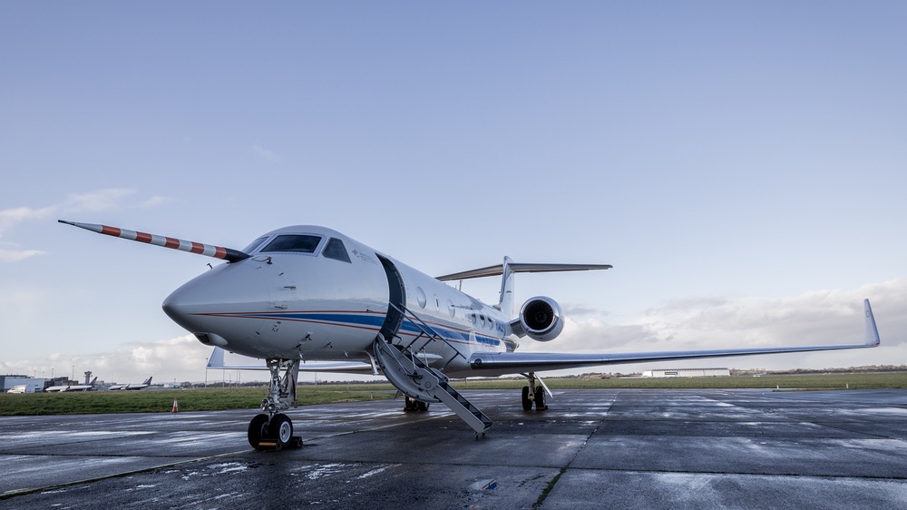
At the heart of the campaign is HALO, Germany’s high-altitude, long-range research aircraft, which is criss-crossing storm systems far out over the ocean to understand how extreme winter weather takes shape.
Why North Atlantic storm formation remains hard to forecast
Europe’s winter weather is dominated by low-pressure systems that develop over the Atlantic before racing eastwards. These systems are fuelled by sharp contrasts between warm ocean waters and cold polar air, often intensified by fast-moving upper-level winds that steer storms towards the continent.
The problem for forecasters is that many of the key processes occur well beyond the reach of routine observations. There are few weather stations over open ocean, limited radar coverage, and only sparse measurements of what is happening vertically inside storms.

The consequences of that data gap are familiar. In the second week of January 2026, Storm Elli swept across Germany and neighbouring countries, forcing train cancellations, closing schools, and causing widespread disruption. Events like this are not unusual, but predicting their severity and timing remains a challenge.
NAWDIC aims to change that by taking measurements where weather systems are born, rather than waiting until they arrive over land.
HALO Gulfstream aircraft brings long-range storm research capability
The campaign relies heavily on HALO, operated by the German Aerospace Centre (DLR). Unlike conventional research aircraft, HALO is based on a Gulfstream G550 business jet, modified into a flying laboratory capable of operating at altitudes of up to 14–15 kilometres and flying more than 8,000 kilometres in a single mission.
There is a neat symmetry here. The aircraft is a Gulfstream, while one of the Atlantic’s most influential features is the Gulf Stream, the warm ocean current that helps moderate Europe’s climate. While the two are entirely different phenomena, both play a role in shaping the weather patterns NAWDIC is trying to understand.

HALO’s combination of altitude, endurance, and payload makes it uniquely suited to the task. It can fly above developing storms, sampling the atmosphere from the lower stratosphere down to the ocean surface, while carrying a suite of sophisticated remote-sensing instruments.
For the duration of the campaign, HALO is operating from Shannon Airport in Ireland, giving it direct access to a wide swathe of the North Atlantic.
How HALO uses lidar to probe Atlantic winter storms
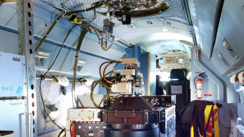
Among HALO’s most important tools are lidar systems developed by the DLR Institute of Atmospheric Physics.
These laser-based instruments allow scientists to build continuous vertical profiles of wind, humidity, and ozone beneath the aircraft, even in remote regions with no other observations.

Two systems are central to NAWDIC. WALES measures water vapour, a key ingredient in storm development, while HEDWIG, a wind lidar, is being flown on HALO for the first time. Together, they allow researchers to see how air masses move and interact inside weather systems.
“As part of NAWDIC, we aim to investigate processes that are not yet fully understood and that can cause severe winter weather events with significant impacts on society and the economy in Europe,” says Andreas Schäfler from the DLR Institute of Atmospheric Physics. “To do this, we combine innovative measurement methods with the unique capabilities offered by the HALO research aircraft.”
Dry intrusions and their role in Europe’s extreme winter weather
A major scientific focus of NAWDIC is a phenomenon known as a dry intrusion. These are streams of dry, often stratospheric air that descend rapidly into developing storms. In winter, dry intrusions can intensify winds, trigger turbulence, and enhance heavy rainfall.
Despite their importance, dry intrusions are difficult to observe and remain a significant source of uncertainty in forecasting models.
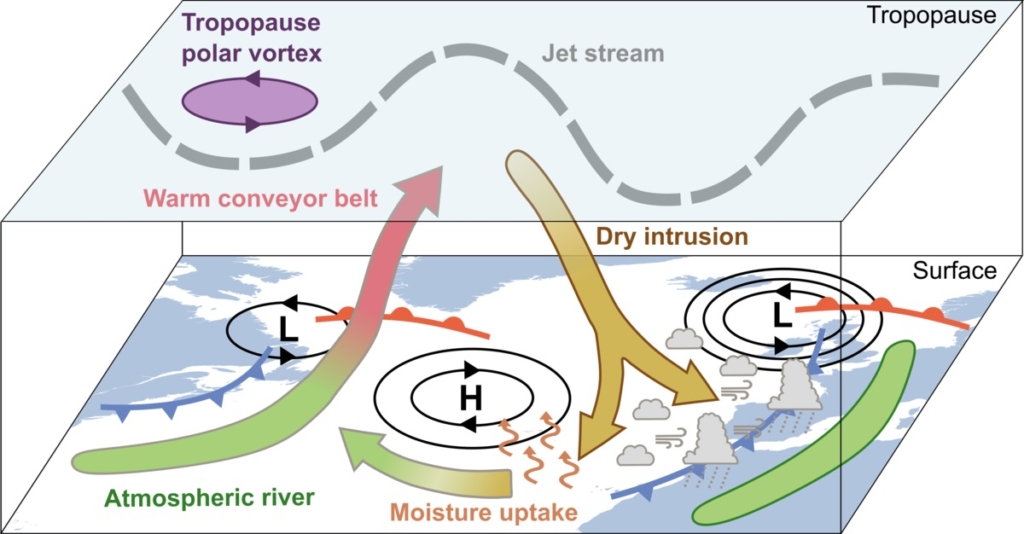
By flying repeatedly through these regions, HALO allows scientists to track how dry air interacts with moist Atlantic systems and how those interactions influence the weather downstream over Europe.
Improving the representation of these processes is not just an academic exercise. Better forecasts of storms and cold spells are critical for public safety, emergency planning, and the protection of critical infrastructure.
NAWDIC brings international cooperation to Atlantic weather research
NAWDIC is led by the Karlsruhe Institute of Technology, with major support from DLR and contributions from more than 30 research institutions across Europe and North America. More than 100 scientists are involved in planning flights, operating instruments, and analysing data.
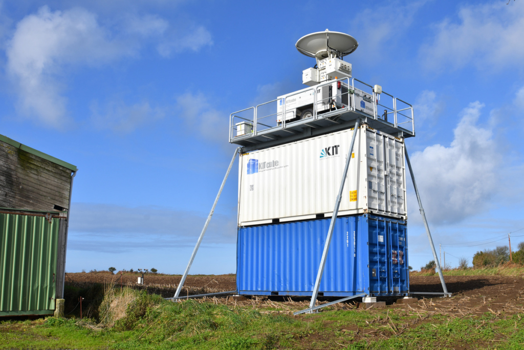
Airborne measurements are complemented by ground-based observations. KIT’s mobile atmospheric observation system, KITcube, has been operating in Brittany, France, since late 2025, monitoring the lower atmosphere as Atlantic systems approach land. Together, aircraft and ground measurements provide a three-dimensional picture of storm evolution.
The campaign also links with other meteorological missions in North America, coordinated over several years with the World Meteorological Organisation. During January and February 2026, as many as ten research aircraft will be flying simultaneously across the Pacific, North America, and the Atlantic, following weather systems from their origins to their impacts.
Operating a research aircraft safely over the busy North Atlantic
Conducting research flights over the North Atlantic is as much an operational challenge as a scientific one.
The region is crossed daily by dense transatlantic air traffic, with flight routes that shift according to winds and weather. Radar coverage is limited, and coordination with multiple air traffic control centres is essential.

DLR’s Flight Experiments facility manages this complexity, ensuring HALO can safely integrate into international airspace. Pilots rely heavily on data-based communication, adapting flight plans in real time to changing conditions while maintaining precise positioning for scientific measurements.
HALO builds on a decade of global atmospheric research missions
HALO has been operating since 2010 and has become a cornerstone of German and international atmospheric research. It has flown missions from the tropics to the Arctic, studying everything from cloud formation and aerosols to atmospheric chemistry and climate processes.
Most recently, HALO supported the commissioning of the European-Japanese EarthCARE satellite, flying beneath the spacecraft to validate its instruments over regions such as Cabo Verde and the Caribbean. Those missions demonstrated HALO’s ability to bridge the gap between satellite observations and in-situ measurements.
NAWDIC builds on that experience, applying the aircraft’s capabilities to one of the most pressing challenges for Europe: understanding and predicting extreme winter weather.
Turning Atlantic storm data into better European winter forecasts
Ultimately, the success of NAWDIC will be measured not just in terabytes of data, but in how that data improves weather and climate models. Aircraft measurements provide the fine-scale, three-dimensional information needed to test whether models correctly capture the processes driving storms.
By reducing uncertainties over the Atlantic, researchers hope to improve forecasts days in advance, giving communities more time to prepare for severe weather.
As winter storms continue to test Europe’s resilience, HALO’s flights over the Atlantic represent a quiet but crucial effort: chasing the weather before it reaches land, and turning observations into knowledge that could make future winters safer.
Featured image: DLR


