UK Met Office trials integrated aviation weather visualisation service

The Met Office has begun public beta testing of a new digital platform intended to replace several long-standing aviation weather services with a single, consolidated interface.
The system, known as the Met Office Aeronautical Visualisation Service, or MAVIS, is being developed as part of a wider modernisation programme covering the UK’s regulated meteorological services for aviation.
Modernising the UK Met Office aviation weather service
At present, UK aviation weather information is accessed through a mix of legacy platforms created at different times and for different user groups, ranging from airline dispatch teams and offshore helicopter operators to glider pilots and balloonists.
That fragmentation has long been a source of complexity, particularly as the volume and timeliness of meteorological data have grown in line with industry demands for more granular, near-real-time weather insights.
MAVIS is intended to streamline that process by drawing together four existing services – Aviation Briefing Service, Network Weather Resilience, Helibrief and Open Runway – into a single, configurable interface.

Beta version of MAVIS available to use now
The beta version of MAVIS, made available from 1 October 2025, offers early access to a prototype software, though the UK agency stresses that the tool “must not be used operationally” while testing continues.
Users can register through the dedicated portal and provide feedback as features roll out.
All four previous generations will be withdrawn in spring 2026 once the new system reaches operational maturity.
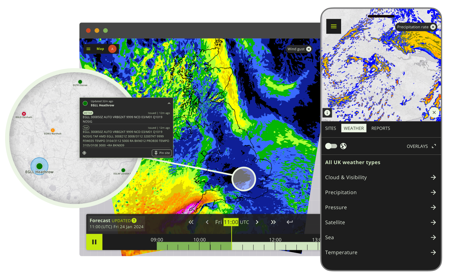
According to the Met Office, the future platform will offer one entry point for aeronautical weather visualisation, with access to observations and forecasts such as METARs, TAFs, atmospheric charts and geospatial weather layers.
Users will be able to tailor the display to their operation, an increasingly common feature across next-generation aviation briefing tools as operators seek quicker decision-making during changing weather conditions.
Integrating customer feedback into the design
The agency says development has been shaped heavily by customer consultation, describing the goal as “a more user-focused product – customer research is directly feeding into the development of the service, making for a more user-friendly, intuitive product.”
Bringing multiple tools together is also intended to reduce inconsistency between products that were originally built in isolation, improving coherence in the presentation of critical weather information.

Among the planned features are modernised graphics, mobile accessibility, configurable map layers and a system of threshold-based colour-coded site icons to flag when parameters such as wind, visibility or cloud height exceed preset limits.
The Met Office says “site icons on the base map change colour if pre-defined weather thresholds for wind, visibility, cloud and weather types, have been met or exceeded,” while users will also be able to pin frequently accessed aerodromes or overlays for faster briefings.
Reducing workload while providing more data
The shift aligns with a broader movement among national meteorological services and ANSPs to modernise briefing and situational-awareness platforms.
Many agencies – such as Météo-France, Germany’s DWD and Australia’s BOM – have in recent years retired legacy text-based systems in favour of interactive digital dashboards, allowing crews and operations centres to access greater volumes of data without increasing workload.
The UK’s introduction of MAVIS follows similar trends as aviation increasingly relies on blended observational data, automated reporting and higher-resolution weather models.
The Met Office says the new system is designed to support decision-making across a broad spectrum of aviation users, from major carriers and airport operations teams to GA pilots.
The public-beta phase will continue while the agency integrates further datasets ahead of the full transition in 2026.
The launch of MAVIS comes as the Met Office is introducing a new forecasting capability designed to significantly cut the scale of disruption from volcanic ash events.
The Met Office is among the first of the nine global Volcanic Ash Advisory Centres (VAAC) to adopt new international standards requiring higher-resolution Quantitative Volcanic Ash (QVA) forecasts.
Produced jointly with VAAC Toulouse, the service will deliver detailed concentration data for 12 atmospheric layers up to around 60,000 ft, along with guidance showing the likelihood of ash exceeding specific thresholds.
Featured image: Met Office