Met Office volcanic ash forecasts aim to cut disruption from future eruptions

November 27, 2025

Fifteen years after the eruption of Iceland’s Eyjafjallajökull volcano brought European aviation to a standstill, the Met Office is introducing a new forecasting capability designed to significantly cut the scale of disruption should a similar event occur again.
The 2010 eruption demonstrated how volcanic ash can rapidly force the closure of vast areas of airspace.
Met Office launches new volcanic ash forecasting programme
Now, the Met Office will begin providing a new type of volcanic ash forecast intended to halve the level of disruption experienced during the 2010 crisis.
As the London Volcanic Ash Advisory Centre (VAAC), the Met Office provides official ash forecasts for eruptions originating in Iceland and parts of the North Atlantic.
These forecasts are used by airlines, air navigation service providers and aviation regulators to determine where aircraft can operate safely while minimising unnecessary restrictions.
The Met Office is among the first of the nine global VAACs to adopt new international standards requiring higher-resolution Quantitative Volcanic Ash (QVA) forecasts.
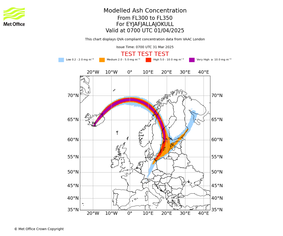
Produced jointly with VAAC Toulouse, the service will deliver detailed concentration data for 12 atmospheric layers up to around 60,000 ft, along with guidance showing the likelihood of ash exceeding specific thresholds.
These improvements reflect advances in engine certification, which now allow aircraft to operate safely in defined low-ash environments.
‘Disruption from Eyjafjallajökull would be half that today vs 2010’
Mark Seltzer, Expert Operational Lead for VAAC London, said: “As we saw in 2010, volcanic ash eruptions in the north-east Atlantic can cause major air travel disruption due to dense flight routes and high seismic activity, resulting in widespread delays and cancellations between the UK, Ireland, Europe, the Far East and North America. And then of course there are the secondary impacts of those cancellations to the public, businesses, hospitality and the tourist industry.
“With our new service, we estimate that the disruption today from an eruption of Eyjafjallajökull would be half of that experienced in April 2010.”
The enhanced modelling capability includes a fourfold increase in vertical levels, more frequent forecast updates and finer horizontal resolution.
The service will be available globally at no cost to airlines and aviation users, supporting more precise decision-making and keeping airspace open wherever safely possible.
Karen Shorey, a Met Office aviation specialist, said: “QVA data will help airlines make more informed decisions to avoid higher concentrations of ash, and will minimise the airspace that needs to be closed in the event of a future eruption.”
What is volcanic ash and how dangerous is it?
Volcanic ash is made up of tiny shards of rock and glass, carried high into the atmosphere, which can spread across vast areas and flight levels within hours.
When drawn into jet engines, volcanic ash can melt, fuse onto turbine components, and in extreme cases cause loss of engine power.
Even at lower concentrations, ash can damage sensors, cockpit windscreens, and airframes, meaning aircraft often must avoid the affected airspace.
Just this week, a vast plume of volcanic ash from Ethiopia’s Hayli Gubbi volcano has triggered disruption across international air corridors linking India, the Gulf and Europe, creating one of the most significant ash-related aviation events in recent years.
The India Meteorological Department (IMD) confirmed that the ash cloud, travelling at 100 to 150 kmph, drifted across the Red Sea and Arabian Peninsula before entering Indian airspace over Gujarat and Rajasthan. It later reached Delhi-NCR, Punjab, Haryana, Uttar Pradesh and Maharashtra.
The ash has interfered heavily with aircraft routing, causing diversions, delays and precautionary cancellations.
Featured image: Adobe